This is an old revision of the document!
Land Navigation
By: Thendash
PREFACE
'Land Navigation' aims to instruct members on performing basic land navigation duties. The author of this document does not recommend that a reader attempt to use the techniques described henceforth in real life situations and as such you do so at your own risk.
SCOPE
This guide contains information on map reading and land navigation techniques, primarily as they pertain to ArmA.
MAP READING
INTRODUCTION
Maps provide information on the existence, location of, and the distance between ground features. It also indicates variations in terrain, heights of natural features, and the extent of vegetation cover. They will be your primary tool in use during land navigation and therefore you must be familiar with all aspects of a map and how to read them.
TYPE
The map used in ARMA 3 is a variable scale, topographic map using a simplified MGRS(Military Grid Reference System). Compared to real life maps, the ARMA map differs in a few ways, primarily:
- No difference between magnetic North and true North.
- No magnetic declination to account for.
- No grid zone designator to account for.
SYMBOLS AND MARGINAL INFORMATION
Margin
The only marginal information on the ARMA 3 map, is scale and contour line distance.
Symbols
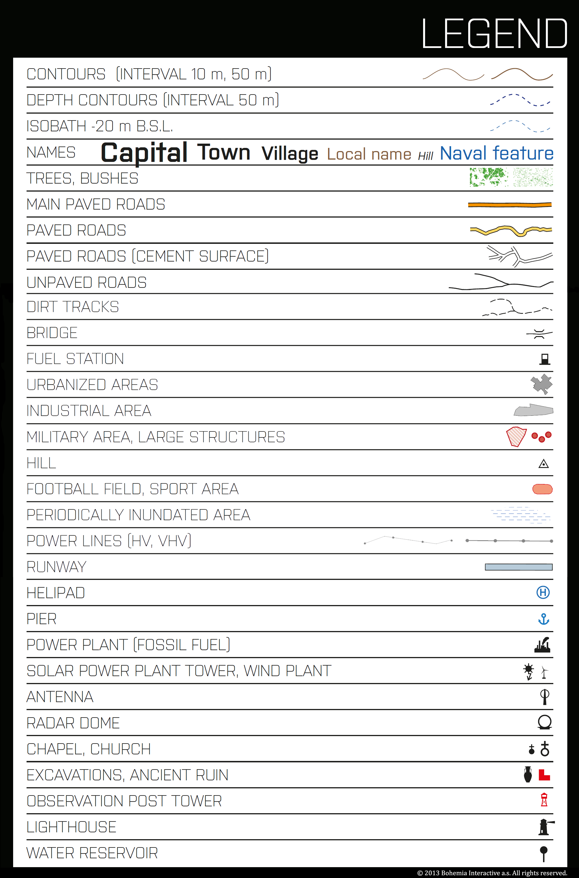
Because it is often not practical to show certain objects at scale on a map, or because more information than just the shape and size of an object is required, symbols are commonly displayed on the map.
Common symbols seen on the ARMA map are categorized into two categories, man made objects and natural objects.
Symbols representing man made objects include:
- Primary Paved Roads(MSR)
- Paved Roads(ASR)
- Dirt Roads
- Foot Paths
- Town and City Centers
- Buildings and Walls
- Prominent Vertical Structures(Antenna, Wind Generator, Lighthouse, etc)
- Runways and Airports
Symbols representing natural objects include:
- Contour and Elevation
- Mountain Peaks
- Water Features
- Forested Areas
- Brush
GRIDS
Reading a grid reference is essential to locating and communicating positions in the world onto a map.
Precision
The map is divided into equally sized grid squares, and the intersecting lines are numbered both vertically(Eastings) and horizontally(Northings). Each digit of a grid reference represents one decimal place, starting at 10 km with the two digit grid reference.
- 10 km square: 2 digit reference
- 1 km square: 4 digit reference
- 100 m square: 6 digit reference
- 10 m square: 8 digit reference
- 1 m square: 10 digit reference
Reading a grid
It is easy to read 2, 4, and 6 digit grid references from the ARMA map because the map scales as you zoom in and out, but you can read a more precise grid reference using either map tools or estimation. Either way, the steps remain the same:
- Read LEFT TO RIGHT first
- Read BOTTOM TO TOP second
- Combine the two readings together to create the grid reference.
These steps can be remembered by the mnemonic, ‘RIGHT in the house, UP the stairs’
ELEVATION
Contour Lines
Elevation on the map is represented by contour lines. ARMA uses two types of contour lines:
- Index Lines: Starting at sea level, every fifth contour line is considered an Index Line and is shown in red on the map.
- Intermediate Lines: All contour lines between the index lines are considered intermediate lines and are spaced at the current contour interval.
Contour Interval
You can find the ‘contour interval’ in the bottom right margin on the ARMA map. The contour interval represents the vertical distance between any two adjacent contour lines at the current map scale. Thus, the closer the contour lines are grouped, the steeper the slope is because more vertical distance is covered in a shorter horizontal distance.
Contour lines never intersect because any point on a contour line is at the same elevation above or below sea level.